


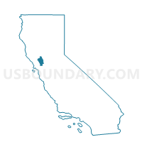
Voting District 40421, Napa County, California
About
Outline

Summary
| Unique Area Identifier | 535566 |
| Name | Voting District 40421 |
| County | Napa County |
| State | California |
| Area (square miles) | 0.48 |
| Land Area (square miles) | 0.15 |
| Water Area (square miles) | 0.33 |
| % of Land Area | 31.53 |
| % of Water Area | 68.47 |
| Latitude of the Internal Point | 38.50174620 |
| Longtitude of the Internal Point | -122.11967080 |
Maps


Graphs
Select a template below for downloading or customizing gragh for Voting District 40421, Napa County, California


Neighbors
Neighoring Voting District (by Name) Neighboring Voting District on the Map
- Voting District 30230, Napa County, CA
- Voting District 30370, Napa County, CA
- Voting District 40370, Solano County, CA
- Voting District 40420, Napa County, CA
Top 10 Neighboring County Subdivision (by Population) Neighboring County Subdivision on the Map
- Napa CCD, Napa County, CA (115,175)
- Vacaville CCD, Solano County, CA (100,015)
- Lake Berryessa CCD, Napa County, CA (1,806)
Top 10 Neighboring Unified School District (by Population) Neighboring Unified School District on the Map
- Napa Valley Unified School District, CA (115,531)
- St. Helena Unified School District, CA (9,714)
- Winters Joint Unified School District, CA (8,845)
Top 10 Neighboring State Legislative District Lower Chamber (by Population) Neighboring State Legislative District Lower Chamber on the Map
Top 10 Neighboring State Legislative District Upper Chamber (by Population) Neighboring State Legislative District Upper Chamber on the Map
Top 10 Neighboring 111th Congressional District (by Population) Neighboring 111th Congressional District on the Map
Top 10 Neighboring Census Tract (by Population) Neighboring Census Tract on the Map
- Census Tract 2529.03, Solano County, CA (4,368)
- Census Tract 2018, Napa County, CA (1,806)
- Census Tract 2014.03, Napa County, CA (800)